Triton Island "Runway" Likely Tidal Levee
Share article


This article was written from the perspective of William Conroy, Ursa Space's Maritime Product Lead.
Previously, Bill has worked at the National Geospatial-Intelligence Agency's Maritime Safety Office and is a veteran of the US Coast Guard.
Ray Powell reached out to me this morning to get my opinion on an "alleged airfield" under construction on the Chinese held Triton Island.
While China is known for building airfields on small islands in the South China Sea, I would like to propose an alternative hypothesis that this construction is a tidal levee that will protect lower lying areas of the southern side of the island from tide waters that enter from the north.
An article, which was published on August 15th, 2023 at The War Zone, recently asserted that China is building another airfield on yet another tiny island in the South China Sea, this time on Triton Island. This island is different from China's "big three" outposts in the Spratly Islands (Subi Reef, Fiery Cross Reef, and Mischief Reef) in that it's in the Paracel Islands, a grouping of islands that's more than 700km northwest of the Spratlys.
The Paracels have not seen large island building projects to the extent seen in the Spratlys, and the construction of a new airbase in the area would indeed raise eyebrows. The author correctly points out that this is close to Vietnam and could point to such things as a change in Chinese security policy towards Vietnam.
My first questions when I saw this "airstrip" were "Why build it oriented this way, and not NE/SW along the longest axis of the island?" and "If it's not an airstrip, why is it built at this orientation?"
China's "big three" South China Sea outposts are all famous for much longer runways that barely fit onto the longest part of the island, with facilities that somehow find a place somewhere around it. The more I thought about it, the more I felt this airstrip theory was less plausible.
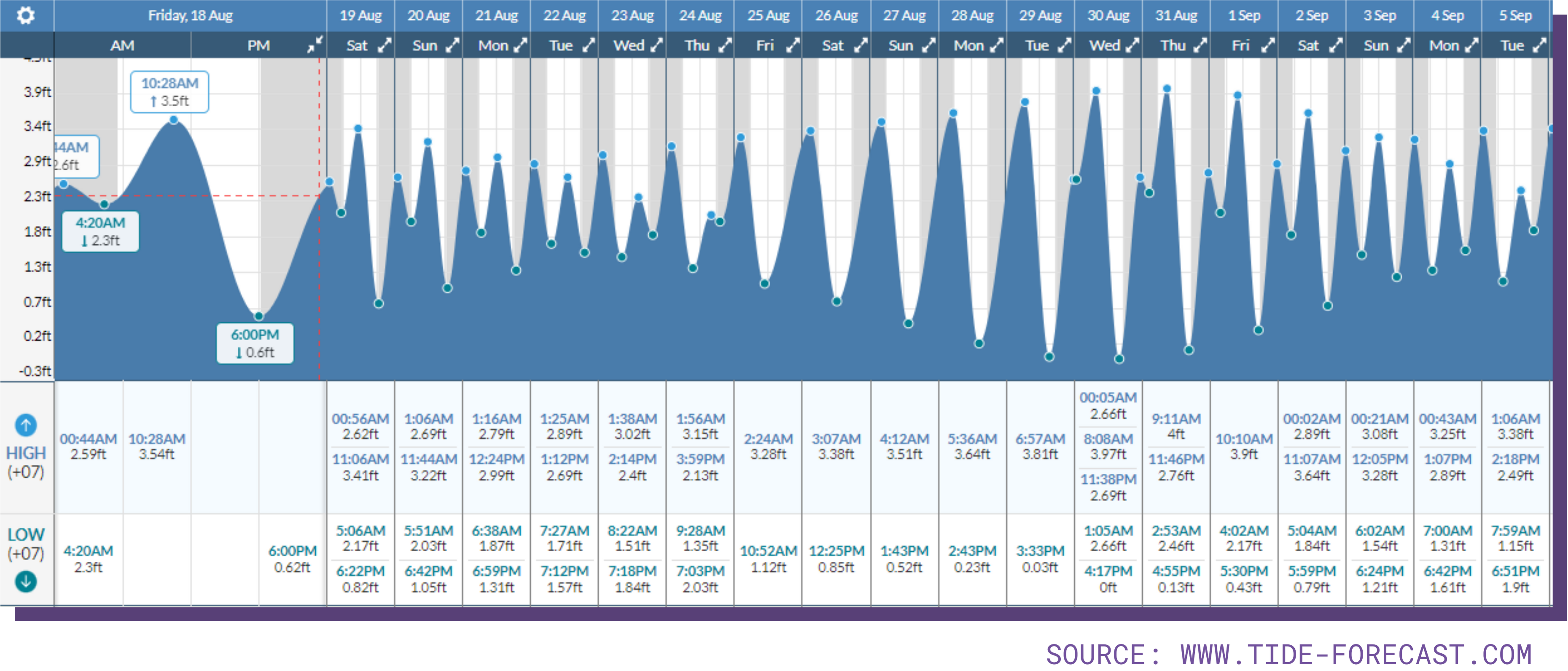
That being said, I knew these islands are very low lying, and I started to wonder what the tidal situation is on Triton. Awareness of tides and currents is very crucial to safe shipboard navigation, particularly in the South China Sea, which is famous for shoals and islands such as Triton which rise steeply out of the seafloor only to barely peek out above sea level. A quick look at a month long tide table from nearby Hoi An, Vietnam showed a maximum high tide of 4ft. Certainly not much on a global standard, but definitely enough to effect a low lying island such as Triton.
I decided going through Google Earth's convenient historical imagery might yield some insights into the effects the tide has on Triton, and luckily the first two images showed evidence of two very different tidal conditions.
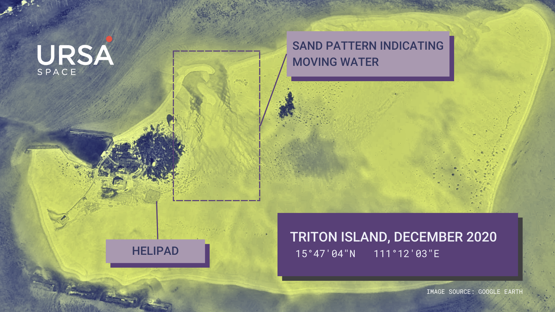
The first image on Google Earth, dated December 2020 and shown below, shows Triton at a low tide state. However, if one looks closely, the image is high quality enough to clearly distinguish sand patterns that indicate water that was flowing straight north to return to the sea, a direction generally perpendicular to that of the alleged "runway."
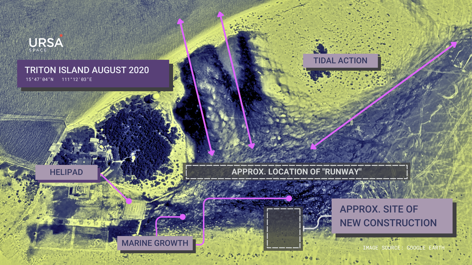
The next image available, dated August 2020, while not exactly at high tide, clearly shows evidence of the extent of a very high tide that likely reaches the already constructed helipad. I've added the approximate location of the "runway" and the new construction site seen in the images from the "War Zone" article to the image below.
Marine growth is very clearly visible in areas south of the "runway" and indicate that these areas do receive sea water at intervals frequent enough to bring to shore or support marine growth at high tides.
Additionally, when one looks at post-construction images in the "War Zone" article (I won't post them here to avoid whatever restrictions might exist), one can clearly see that marine growth still exists, however it stops at the "runway" (which I will now refer to as a "levee" from here on out) and does not appear south of it.
Due to the presented evidence, I am highly confident in saying that the construction seen in these images on Triton Island likely represents a tidal control levee that allowed the construction of the new facility seen to the south the levee while additionally protecting already existing facilities at the outpost.
Thanks again to Ray Powell for this interesting question. Please reach out to Ursa Space Systems if you have any GEOINT needs or questions.
Share article